The Walk through Roeburndale Woods
Walking
Forest of Bowland ViewRanger
Many farmers in Roeburndale have created permissive footpaths which lead visitors through our wonderful landscape.
These link with a network of public footpaths:
Within 20 mins walk you can reach open access land rising up onto the fells of the Forest of Bowland.
Roeburnscar is located at Grid Reference SD60561 66842.
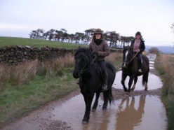
Horse Riding
There are some interesting quiet roads that you can ride on leading up to Botton and Lowgill.
A permissive bridle way goes through Backsbottom Farm to further up the valley-this links into the North Lancashire Bridle Way.
The Forest of Bowland Authority have produced a leaflet on Horse riding in the area.
Cycling
This area is excellent for cycling and is adjacent to the Lancashire Cycle Way.
The Millenium Cycle way leads into Lancaster and the Way of Roses passes nearby.
For details see the Forest of Bowland's excellent Cycling page with details of routes.
Forest of Bowland ViewRanger
Many farmers in Roeburndale have created permissive footpaths which lead visitors through our wonderful landscape.
These link with a network of public footpaths:
- Forest of Bowland Walking information
- Roeburndale Walks
- For map and aerial photo Open and then type in "Wray Lancashire", Then press search button. Roeburnscar is 1 Km south of Wray in the woods by the river. (Just slightly South West of the A in Alcocks Farm)
- Backsbottom Farm - near Lancaster
- Bowskill Wood
- Barkin Gate Farm - Our Neighbouring farm
- Walks in Wenningdale, Hindburndale and Roeburndale
- Local Walks
- iFootpath walking guides website
Within 20 mins walk you can reach open access land rising up onto the fells of the Forest of Bowland.
Roeburnscar is located at Grid Reference SD60561 66842.
Horse Riding
There are some interesting quiet roads that you can ride on leading up to Botton and Lowgill.
A permissive bridle way goes through Backsbottom Farm to further up the valley-this links into the North Lancashire Bridle Way.
The Forest of Bowland Authority have produced a leaflet on Horse riding in the area.
Cycling
This area is excellent for cycling and is adjacent to the Lancashire Cycle Way.
The Millenium Cycle way leads into Lancaster and the Way of Roses passes nearby.
For details see the Forest of Bowland's excellent Cycling page with details of routes.


